If you live in a Western state, your ancestors may have moved there during the great Westward Expansion. These early American pioneers traveled thousands of miles on land by covered wagon, horseback, or even on foot to arrive where you are now.

With a Westward Expansion map as a resource, you can trace your family history to learn whether your relatives were settlers that forged trails traversing the continent to the Pacific, creating the United States nation as it is today.
Who Were the Pioneers?
The pioneers were made up of all types of Americans living across the Eastern United States who made the decision to embark on an expedition and move west when the United States began expanding in the early 19th century.
Many of these Americans were simply looking to become landowners, as the country – after the Louisiana Purchase of 1803 – suddenly contained a wealth of newly available farmland perfect for territorial expansion. Others were looking to escape religious persecution, most notably the Mormons who moved west in a large wave. Some traveled west to California during the gold rush that began in 1849, hoping to strike it rich.
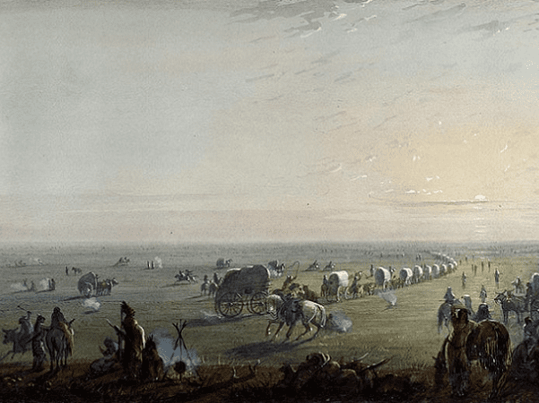
All of these different groups suffered similar hardships, as the journey west was extremely perilous with disease, violence, and harsh weather threatening the pioneer caravans. The majority made the trip in a covered wagon, which has become emblematic of a pioneer family.
Westward Expansion States and Trails
Pioneers during the Westward Expansion usually began their journey in either Missouri or Illinois. The major trails passed through various states, including Nebraska, Kansas, Utah, Idaho, Wyoming, Colorado, New Mexico, and Arizona, ending up in Nevada, California, Oregon, or Washington.
The Major Trails
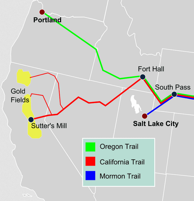
Pioneer settlers took a number of different trails on their journey west. However, there were several that are historically significant because of their popularity at the time. National Geographic provides a westward expansion trails map that can be useful in determining whether your ancestors used them to move to your current home. Here is an overview of these main trails and the states that were involved.
The Oregon Trail – This famous trail started in Missouri and moved through the Northern part of the United States, finishing in what is now Oregon and Washington. It was big enough to sustain large caravans of covered wagons, thus popular with pioneer families. If your family currently resides in Oregon or Washington, there is a good chance that they moved west on the Oregon Trail. Some also moved on to California.
The Mormon Trail – This trail gets its name from Mormons seeking refuge in Salt Lake City, Utah. Many Mormons were cast out of their original communities due to religious persecution, so they moved west as a group and ended up in Utah, establishing a vibrant community there. Additionally, many settlers utilized the Mormon Trail and continued on to Nevada and Southern California.
The California Trail – Stretching from Missouri to Northern California, this trail passed through the Great Plains up into the Rockies and was commonly used during the Gold Rush. If your family lives in Northern California, it is possible that they came there on the California Trail.
The Santa Fe Trail – While this trail was initially geared toward trade, it became a popular route for pioneers and connected Missouri with Santa Fe, New Mexico. It also enabled economic expansion as it was a prominent route for the transportation of goods. Many of the pioneers that used the Santa Fe Trail settled in Colorado and New Mexico, while some continued further west on the Gila Trail or Old Spanish Trail.
While your family may have moved west on any of these major trails, there were various other routes that were utilized throughout the period of the Western Expansion.
Of course, the final destination of these trails does not dictate where all the pioneers ended their journey. Many families stopped along the way, establishing communities in the various states that these trails passed through. Take a look at the Westward Expansion trails map to determine how your ancestors may have arrived at your home state. Take your research a step further and search the 1800 census to uncover even more details about your ancestors.
Where Does Your Family Fit?
Whether your family fits into the U.S. Westward Expansion map depends on when your family moved west. The pioneer Westward Expansion is generally limited to the 1800s and includes all of the states west of the Mississippi River. The railroad increased immigration to Western states to record levels when the Transcontinental Railroad was completed in 1869, so it is possible that your ancestors moved to where you live now after the Westward Expansion of the early pioneers.
If you want to uncover your ancestors’ specific journey, or have further questions, you can search through publicly available census data from the National Archives and US census records, or employ a genealogy research company that can compile pioneer records from the 19th century. There is a large amount of information available on the early pioneers that can help you tell your family’s story, so begin your own pioneer journey now to learn more about your ancestors and your heritage.
Sources:
- Family Search: Family Search Research Wiki – Trails
- National Archives: Exploration and Westward Expansion
- National Archives: Research for Genealogists
- National Geographic: Trails West
- Nature Communications: Clustering of 770,000 genomes reveals post-colonial population structure of North America
- GenealogyBank
Related Articles:
